Translate

Sunday, December 29, 2013

Poster Art and Holiday Greetings


Alan and Cyane's holiday greeting card to left.
It is based on the poster shown below, which was put up to auction at Swann Galleries in New York in December.


The poster to right is by Josef Hoffmann and was done for the Wiener Werkstatte workshop in Vienna around 1905.  The colony of artists had as its objective 'the fabrication of exquisitely wrought and wonderfully designed everyday objects.  Envisioned as a close collaboration of artisans and craftsmen that would champion handmade work over machine-made mass-produced items."


The poster below was one of our favorites at the Swann Gallery sale.  http://www.swanngalleries.com/3dcat/2336

The Beit Company was started by Ferdinand Beit Sr (1817-1870), a Hamburg Germany chemist, entrepreneur and import-exporter from a Jewish family.  He started a number of businesses, including fertilizer, paints and book and stone inks.  His son Ferdinand Beit Jr (1858-1928) carried on the business; this poster is from 1901.  Ferdinand Beit Jr was also active in local politics on the left and working against anti-Semitism.  This advertising poster is interesting as the colors are those of the German flag and the lady is looking to the left!


Christmas Contrasts, December 2013

 Homemade Christmas Pine Trees with an 'outcrop' of paper and leaves.


To right, the Met Life building dolled up Christmas tree.

Above, the Lafayette Inspirational Ensemble from Brooklyn, NY.

Below, the grand stairs at the Metropolitan Opera.


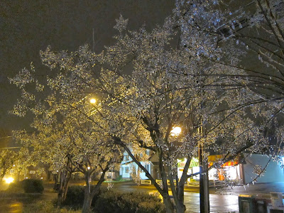
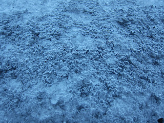
Winter Weather: December 2013 in Philadelphia

These photos show a spectrum of light and precipitation conditions (often fluctuating around the freezing point).  The first shot was at night after freezing rain, the second and third shots around sunset after a real snow.  The last picture is of bubbles frozen on road ice on a cold and slippery morning.  


Saturday, November 30, 2013

Clouds in the Landscape I

 This photo was taken on the last day of November, 2013.  
While artful in its way, it is unsettling.
All the clouds on that morning were caused by jet condensation trails.
It is a modern skyscape.


 Charles Sheeler, 1931, Classic Landscape

 Hendrik Willem Mesdag, 1894, Sunset at Scheveningen


Gustave Courbet, 1865, The Black Rocks at Trouville


Eugene Boudin, 1864, The Beach at Villerville

Clouds in the Landscape II

More great paintings from the National Gallery of Art, still on the theme of clouds.


 William Turner, 1844, Approach to Venice

John Constable, 1816, Wivenhoe Park, Essex


William Turner, 1807, The Junction of the Thames and the Medway


Pierre-Henri de Valenciennes, 1782, Study of Clouds over the Roman Campagna

Philadelphia Thanksgiving 2013

Philadelphia City Hall from Broad St looking north
Standing Room Only at Reading Terminal Market


Cheese steaks are very popular.

A little quieter and more elegant...

Wednesday, October 30, 2013

October Colors, Philadelphia

There are still Sugar Maples growing in the Chestnut Hill neighborhood of Philadelphia, planted decades ago.  The photo below shows a Sugar Maple bravely displaying its October colors, despite a hard life evident in the shape and form of the tree.


There are many gardens all through Philadelphia.
Below, late Chrysanthemums and Callas at Morris Arboretum:


And, here is a planting that I created with Red Abyssinian Banana, Hot Peppers, Lantana and Leonotis/Lion's Head


Quote for the month, from Ray Bradbury:
"Treasure this day and treasure yourself.  Truly, neither will happen again."

October Skies

To continue the theme of skies, these sunset images offer reminders that stunning beauty occurs in passing moments, even at home.  
In this first photo, the condensation trails from planes are so frequent as to become one of the cloud formations.


The series below was taken at sunset in the same area, just a few minutes apart.


Monday, September 30, 2013

September Sunsets: 2013, Philadelphia

The weather in Philadelphia in Sept 2013 was balmy and clear, dominated by high pressure systems.  Not much rain but some beautiful sunsets.


Golden rays of the setting sun above are reflected and refracted by the cloud bank below.


Setting sun highlights farm buildings, trees, con trails, and the puffy cloud formed by the Limerick Nuclear Plant.  Colors grade from blue through yellow to red.

Below, simple shot to south at dusk shows cloud cover on a warm humid Sept. evening.


Thursday, August 15, 2013

Overview: July-August 2013


The following 30 blog 'chapters' illustrate chronologically the following: 

I.  Champoly, Rhone-Alpes, France:  one post for brief visit to 'Champoly 2013'

II.  2 posts, getting ready for a hiking tour in the towns of  'Sion' and 'Graechen'

III.  Hiking Tour of the Matterhorn:  21 posts:  'Day 1 Augustbordpass' to 'People on the Europaweg Trail'

IV.  In and around Zürich, Switzerland: 4 posts:  Sights, Meals, Ufenau, Schaffhausen

V.  Flight home:  one post

Note:  when you get through all 10 of the blog posts on this page, there are more photos from August.  Just click on "Older Posts" to see the next 'chapter' or click on the title of the blog chapter that you want to see.  Blog chapter titles are listed on the right side under the month and year.
The Tour of the Matterhorn is the densest portion with the most images.
This hike totaled 150 km over 11 days.
Daily average was about 14 kilometers per day, 900 meters ascent and 1,000 meters descent.  (There were two times when we took a cable car or bus to go up.)
Most of the hike was in Switzerland, 3 days in Italy.
Languages German, French, Italian.
Map:  https://maps.google.com/maps/ms?msid=217907250670539717383.0004e407ed113d82791be&msa=0&ll=46.152248,7.715149&spn=0.830513,1.286774

  Day 1:  St. Niklaus - Augstbordpass - Gruben-Meiden
   elevation 1,120 m        2,900 m                1,820 meters 
   total          16 km           1,800 m up            1,100 meters down

  Day 2:  Gruben-Meiden - Meidpass - Zinal
                1,820                     2,800 m      1,675 meters
                 22 km                   1,000 m up  1,200 m down

  Day 3:  Zinal - Col de Sorrebois - Barrage de Moiry
                1,200  2,900 m                   2,300 m
                12 km  1,700 m up              600 m down

  Day 4:  Barrage de Moiry - Col de Torrent - Les Hauderes - (bus to Arolla)
                2,300 m                   2,900 m               1,450 m
                15 km                          600 m up          1,500 m down

  Day 5:  Arolla - Col Collon - Refugio Nacamuli
                2,000 m  3,100 m      2,830 m
               12 km     1,100 m up   300 m down

  Day 6:  Refugio Nacamuli - Prayerer - Col di Valcornera - Rifugio Perucca
                2,830 m                     2,010 m    3,100 m                    2,900 m
                10 km        1,100 m up      1,000 m down

  Day 7:  Refugio Perucca - (Perriere) - Breuil/Cervinia
                2,900 m                   1,900 m     
               9 km            no up               1,100 m down

  Day 8:  Breuil/Cervinia - funivia to Theodulpass - Glacier - Gandegghut
                2,100 m                                 3,317 m                           3,030
                3 km + 6 km stroll                 300 m up                    600 m down

  Day 9:  Gandegghut - Furgg - Hornlihut - Stafelalp - Zermatt
                3,030 m          2,400 m  3,260 m                       1,600 m
                17 km              850 m up                                     2,250 m down

  Day 10:  Zermatt - Ottovan/Taeschalp/Europaweghut
                  1,600 m     2,200 m
                  8 km          800 m up           200 m down

  Day 11:  Taeschalp - Randa - St. Niklaus
                  2,200 m        1,440 m   1,120 m
                  20 km            200 m up   1,400 m down


Favorite Pictures


Josette Valloton, mountain guide from Arolla Switzerland.

 Ghiselaine Bornatici, one of the owners of the Hotel Aiguille de la Tsa in Arolla, takes a break above to go hiking with the professor across the glacier.

Ursula, owner of the Walliserhof hotel in Taesch.

Glacial boulder above Gruben-Meiden in Turtmantal.  First day of the hike.


Champoly 2013


The Chateau d'Urfe is in the small town of Champoly, west of Lyon France.
A volunteer organization works to maintain and conserve the remains of this castle, which was inhabited from the 12th to the 18th century.  Link:  http://www.chateaudurfe.com
For a link to this area showing Champoly, click below:
https://maps.google.com/maps/ms?msid=217907250670539717383.0004ab07f5bc974b50243&msa=0&ll=45.85176,3.834229&spn=3.340084,5.147095


Every summer a band of volunteers works on construction of the chateau through the organization Rempart.  Info on their website at http://www.rempart.com
We volunteered and worked on the chateau 2009, 2010 and 2011.

The photos above and to the left show the team from 2013.

Gaby and Georgette have worked for many years to support the Association.


Sion

Going east up the Rhone Valley from the Lake of Geneva are the towns of Martigny, Sion, Sierre, Visp and Brig.  We chose Sion as a point to prepare for the hiking trail Tour of the Matterhorn, even though the tour departs from the valley south of Visp.  
Sion has a fascinating history, one of the most important sites of prehistoric settlement in Europe.  Information at:  http://en.wikipedia.org/wiki/Sion,_Switzerland    
It was settled by 6,000 BC in Neolithic times, became an important Roman settlement, and was Christianized in the fourth century.  Its strategic location has made it a site for conflict throughout Swiss history.  
It is now the capital of the canton of Valais/Wallis, whose flag can be seen behind the Swiss flag.  The flag of Valais is split down the middle, just like the actual canton:  the western half French-speaking and the eastern half German-speaking.


It is an easy bus ride from Sion up Val d'Herens to Les Hauderes and Arolla.  We went up to do reconnaissance on our coming hike Tour of the Matterhorn.  Below is Mont Collon near Arolla, and a yellow Pasque flower colonizing the floodplain of the river below it.


Click on this link for a Map of the area around Sion
https://maps.google.com/maps/ms?msid=217907250670539717383.0004e3fc56da5b4d37bb2&msa=0&ll=46.008409,7.877197&spn=1.665351,2.573547