These Walter Gropius 'cantilever' chairs are just some of what Tecta offers.
Translate
Monday, October 31, 2016
Tecta
We made a pilgrimage to central Germany, (in an area between Hanover, Kassel, Goettingen and Bielefeld) to the factory and museum of Tecta. It is a small German company dedicated to celebrating, preserving and producing Bauhaus chairs and furniture.
Tecta Kragstuhl Museum
Kragstuhl apparently means 'cantilever chair' in German.
Here is a museum devoted to the history and celebration of modern chair design, especially Bauhaus steel tubing approaches.
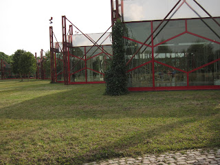
It is housed on the Tecta campus in buildings designed by Peter and Alison Smithson.
And who knows, you might run into Walter Gropius, Marcel Breuer and Wassily Kandinsky at the Tecta Kragstuhlmuseum !
Chairs by Gerrit Rietveld, with an original from his design shop on the left.
Here is a museum devoted to the history and celebration of modern chair design, especially Bauhaus steel tubing approaches.
It is housed on the Tecta campus in buildings designed by Peter and Alison Smithson.
Apparently, the cantilever approach was derived from bicycle steel tubing by Bauhaus designers. It was adapted to the wooden frame on the right by Gropius.
And who knows, you might run into Walter Gropius, Marcel Breuer and Wassily Kandinsky at the Tecta Kragstuhlmuseum !
Chairs by Gerrit Rietveld, with an original from his design shop on the left.
Amsterdam by Boat
We were lucky to be taken on a ride through Amsterdam canals by a friend.
Many of the houses from the 1600's don't look that different.
Many of the houses from the 1600's don't look that different.
Good weather on a late September weekend brought out the party spirit, in locals above and tourists below.
And there is modern architecture to look at, contemporary above and classic 'Amsterdamse School' from the early 1900's below.
Cortina d'Ampezzo
Cortina was the site of the 1956 Winter Olympics and has attracts winter skiers.
It is northeastern Italy in the Dolomite mountains.
There is also summer hiking.
In 2016, we are able to do a short 60 km hike over 4 days.
We hope to return and do more on the long distance Alta Via Dolomiti.
It is northeastern Italy in the Dolomite mountains.
There is also summer hiking.
In 2016, we are able to do a short 60 km hike over 4 days.
We hope to return and do more on the long distance Alta Via Dolomiti.
Cortina to Rifugio Croda di Lago
Cortina d'Ampezzo is about 1,200 meters of altitude.
It is an easy walk up to Lago d'Aial at 1,400 meters and a nice rest stop.
Above, sedges in a little bog.
Most of the path is through spruce-fir forest.
Rifugio Croda da Lago at 2,050 meters.
4 Forclettas and 1 Pass
This was a day of 4 Forclettas (little passes with pathways) and 1 Pass (with road).
We were hiking east to west just south of Cortina on the Dolomite High Path.
Images below were between Forcletta Ambrizzola and Forcletta Giau, at about 2,200 m.
This is after leaving Passo Giau and heading to Forcletta Nuvolau.
Rifugio Nuvolau is visible in the right of the photo - on top of cliff.
After going through Forcletta Nuvolau at 2,400 m, we finally see endpoint Rifugio Lagazuoi.
It is the little dot on the top of the first peak in the center left of this photo, under "k" in peak.
Lagazuoi
Rifugio Lagazuoi is at 2,754 meters on a peak above Passo Falzarego. It is serviced by a cable car funivia and a foot path. No roads.
Below, looking north at the road, the Pass and up to Rifugio Lagazuoi at the top.
Closer view to the southeast, showing Cinque Torri bottom left and Nuvolau to the right.
Below, looking north at the road, the Pass and up to Rifugio Lagazuoi at the top.
From Lagazuoi looking southeast, the direction from which we came.
Closer view to the southeast, showing Cinque Torri bottom left and Nuvolau to the right.
A trail runner at sunset.
Austrian Fortifications at Lagazuoi
The army of the Austrian Hungarian Empire dominated northern Italy before and thru WW I. They had entrenched fortifications on the peak of Lagazuoi, where they could rain bombardment down on the valley road and also on the entrenched Italian position at Cinque Torri. Photo below shows a fort dug into the rock, from which Austrian army could control the road to Falzarego Pass and shoot at the Cinque Torri position visible in the upper left.
Everything had to be dug into the rock or protected by walls against bombs and bullets.
This military position was held for years, winter and summer.
Caves and holes were dug in the rock to live in.
Officers' deluxe quarters below.
At 2,700 meters, Lagazuoi is a barren and forbidding place.
Everything had to be dug into the rock or protected by walls against bombs and bullets.
This military position was held for years, winter and summer.
Caves and holes were dug in the rock to live in.
Officers' deluxe quarters below.
At 2,700 meters, Lagazuoi is a barren and forbidding place.
A Wrong Turn
So, everything was going fine, the trail was interesting, with glacial bogs below and remnants from WW I fortifications.
The first sign that something was wrong: mountain goats, below.
The German climbers visible in photo below turned around and said that it was too steep.
Then we knew that we had made a mistake and were really on the wrong trail.
I was doing the route finding and thought this was the trail, visible below going up the slope.
The first sign that something was wrong: mountain goats, below.
Alan was getting worried as the trail got steeper.
The German climbers visible in photo below turned around and said that it was too steep.
Then we knew that we had made a mistake and were really on the wrong trail.
Mr Mike below came along just at that moment to save the day.
He talked us down off the cliff!
Oh, and did I mention it was Alan's big birthday?
The Right Way Up the Pass
Alan and Michael were happy to reach the small lake Lech di Lagacio at 2,100 meters.
We left Michael to follow his path and took the correct route up to the Forcela Lech (2500m).
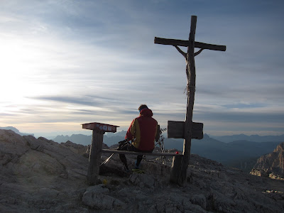
Photo below looking south along path toward Rifugio Lagazuoi, the start of the day.
We left Michael to follow his path and took the correct route up to the Forcela Lech (2500m).
Photo below looking south along path toward Rifugio Lagazuoi, the start of the day.
Le Gran Plan
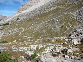
We hiked for 10 kilometers through the large valley Le Gran Plan, along the main pathway through the Dolomites, Alta Via Dolomiti. Altitude about 2,000 meters. The whole hike was a lesson on the massive amounts of moraine that glaciers can leave, and the progression from bare rock to small plants, shrubs and eventually trees.
The amounts of rock in moraines (photos at top) and talus (slope debris shown in photo above) are amazing. The boulders coming off the cliff are as big as houses.
The amounts of rock in moraines (photos at top) and talus (slope debris shown in photo above) are amazing. The boulders coming off the cliff are as big as houses.
Subscribe to:
Posts (Atom)


