These dry gorges in limestone cliffs are remnants of glacial torrents.
Alan can be seen for scale above; the metal ladder in the photo below.
Samoens has a botanical garden, photo above and a nice hostel "Gite les Moulins" run by Mireille, below. The flowers above are Eryngium alpinum and Elecampane/Inula.
Translate
Wednesday, July 18, 2012
Day 9 of GR5 Hke: Servoz to Col Anterne
We left the valley of the Arve and Chamonix, hiking from Servoz at 816 m.
The Chalets de Pormenaz below are at 1925 meters looking northeast to Mt Blanc massif.
Looking the other direction toward Lake de Pormenaz you can see a little white speck that is the refuge under Col d'Anterne.
The refuge is at 2000 meters and has a wonderful view back toward Mt Blanc.
We left the Mt Blanc area two days before a massive avalanche killed 11 people at high altitudes who were climbing the mountain:
Gorges de la Diosaz; on the Arve below Chamonix
We knew of the Gorges of the Diosaz because of the travel poster above, by a favorite French artist Roger Broders. He painted advertising lithographs for about 10 years during the late 20s. When we took the train from Chamonix to Servoz, hiked up the hill, and entered the gorge area, it still looked much the same as it did when Roger Broders painted it:
There was a monument to a young naturalist who died in the gorge area.
Since the monument had been erected during the early years after the French Revolution, the monument below gives the dates using the calender system that the new republic had instituted: the 21st day of the month of Fructidor in the year IX/ beginning of Sept. 1800.
Note that Bonaparte is listed as one of the three French consuls.
Mathamaticians and philosophers together came up with the new calender system.
In the explanation below can be seen the names of the months:
Winter: Nivose, month of snow; Pluvose, month of rain; Ventose, month of wind
Spring: Germinal, month of germination; Floreal, month of flowers; Prairial, month of meadows
Summer: Messidor, month of grain harvest; Thermidor, month of heat; Fructidor, month of fruits
Autumn: Vendemiaire, month of grape harvest; Brumaire, month of fog; Frimaire, frost month:
Year I would have been 1891.
Monday, July 9, 2012
Favorite Pictures from GR5 Hike: Modane to Chamonix
Alpine Lake near Col du Palet, above Tigne near Val dIsere.
Glacial Lake Lac de la Plagne below Col du Palet near Peisey-Nancroix.
This landscape has a very sensual feel to it - how French!
Col du Bresson and Val de lOrmente above Landry in the valley of the Isere.
Sunset at Gite dAlpage Plan Mya.
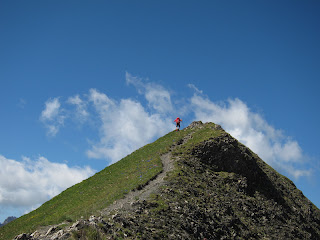
Alan on the Crete des Gittes approaching Mt Blanc.
Cyane at the Col de la Leisse.
A Few Beautiful Flowers from the GR5 Hike
Columbine, Aquilegia above.
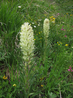
Phyteuma
One of the few Campanula that is white and not blue.
Lily above, with Aruncus or Goatsbeard in the background.
Alpine flowers white Dryas octopetala and Globularia, which is blue.
Phyteuma
One of the few Campanula that is white and not blue.
Lily above, with Aruncus or Goatsbeard in the background.
Alpine flowers white Dryas octopetala and Globularia, which is blue.
Chamonix Mt Blanc Rest Day
The view of Mt Blanc and glacier from the Youth Hostel just south of Chamonix.
The main square of Chamonix at dusk above, and the Chamonix valley with morning clouds below.
The main square of Chamonix at dusk above, and the Chamonix valley with morning clouds below.
Day 8 of GR5 Hike; down to Chamonix-Mt Blanc, Cloudy Day
The Chalet Refuge Nant Borrant, above, is about 1.5 hours outside of Les Contamines, which connects up to the Chamonix valley.
The statue below in Chamonix of two early climbers of Mt Blanc. They point toward the glacier which spills from its side down toward the town.
The statue below in Chamonix of two early climbers of Mt Blanc. They point toward the glacier which spills from its side down toward the town.
Day 7; Plan Mya into the Watershed of Mt Blanc
On a brilliant morning, we leave the glacial outwash plain south of Mt Blanc massif with a French hiking group from Dijon, Mille-Pat.
We leave the French hiking group at the Col de la Sauce and hike on along the Crete des Gittes, below. We are here above 2500 m and you can finally see the base of Mt Blanc in the distance with the summit hidden by clouds.
18 km; 700 m ascent and 1080 m descent.
We leave the French hiking group at the Col de la Sauce and hike on along the Crete des Gittes, below. We are here above 2500 m and you can finally see the base of Mt Blanc in the distance with the summit hidden by clouds.
18 km; 700 m ascent and 1080 m descent.
Day 6 GR5 Hike: Gite dAlpage de Plan Mya
After a long day of hiking on day 6, we were delighted to find a lovely small refuge with good food from the region. Three types of local cheese above after dinner: Tomme, Robuchon, and Beaufort.
The sunset was glorious after an afternoon of clouds and rain.
The next morning dawned clear and we had breakfast with a French hiking club from Dijon.
Gite dAlpage de Plan Mya; LEtraz, 73270 Villard sur Doron; www.refuge-mya.com
Run by Francoise and Yvon Bochet
The sunset was glorious after an afternoon of clouds and rain.
The next morning dawned clear and we had breakfast with a French hiking club from Dijon.
Gite dAlpage de Plan Mya; LEtraz, 73270 Villard sur Doron; www.refuge-mya.com
Run by Francoise and Yvon Bochet
Subscribe to:
Posts (Atom)


